







All the parties involved say ask the Florida Department of Transportation.
The DOT says the issue has been studied and everything is OK.
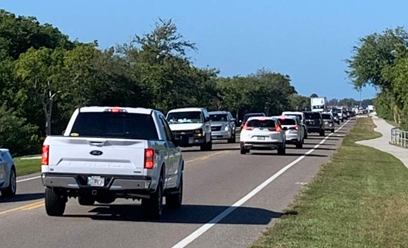
The issue: Will completion of the Compass hotel and Floridays restaurant in the Harbour Isle development on Perico Island in a few months add significantly to the often-choked traffic on Manatee Avenue?
And another question: Is the DOT investigating?
The DOT answer: “Based upon the information contained in the previously approved access permit for this development, which took into account both the development and future build-out traffic, the department does not believe additional analysis is warranted at this time.”
The study, however, was performed in 2011 and the scope and size of the development has grown significantly in eight years.
Taking shape on Perico
The hotel and restaurant are being built on the northern bayfront on Perico Island about a half-mile east of the Anna Maria Island Bridge.
The area is already home to Harbour Isle on Anna Maria Sound, and its three residential developments:
• Mangrove Walk, 132 coach homes.
• Edgewater Walk, 147 coach homes.
• One Particular Harbour, 132 condos.
That brings the total to 411 residences. The development has been approved for 686.
The six-story Compass hotel will have 113 guest rooms and 10 two-room suites, said Angus Rogers, president and CEO of Floridays Development Co.
The hotel will have a resort-sized pool situated between the hotel and the restaurant, all wrapping around the bayfront docks.
The restaurant is slated for 250-275 seats, depending on the arrangement, Rogers told The Islander earlier this month. Both are scheduled to open in the spring, he said.
The area where the hotel and restaurant are being built is zoned commercial and was originally planned to be a strip shopping center.
Minto Communities, under its Latitude Margaritaville Division, is developing the residential segments of Harbour Isle.
Floridays Development Company is heading up the Compass by Margaritaville Hotels & Resorts and the restaurant in partnership with Margaritaville Holdings.
Margaritaville Holdings sold the marina — now Safe Harbor Pier 77 — with 55 wet slips and 128 indoor racks earlier this year to Safe Harbor Marinas, the world’s largest owner and operator of marinas.
Traffic analysis dates to 2011
None of the development entities publicly addressed traffic issues, said William Bullock, president of Minto’s Latitude Margaritaville Division.
“We have no comment on traffic planning as that is a local government and FDOT issue,” Bullock wrote in a Dec. 9 email to The Islander. “Harbour Isle has complied with all traffic requirements to date.”
Mike Belmont, president of Minto Communities, downplayed any traffic concerns in an interview with a Bradenton newspaper in March.
“I don’t think it will be a noticeable thing,” Belmont was quoted as saying in the Bradenton Herald. “We already have about 300 residents who have been living here, and I don’t think it’s made a difference.”
The DOT says traffic on Manatee Avenue, part of State Road 64, has been addressed.
“This development was reviewed and permitted by the department in 2011,” DOT spokesman Brian R. Rick said in a November email to The Islander. “The submittal included a traffic study analyzing project traffic and access to SR 64.”
But aspects of the development have grown since the December 2011 transportation analysis by Tampa-based Lincks & Associates.
For example, the Lincks study noted that the “exact uses within the commercial portion are unknown at this point,” so analysts projected 16,000 square feet for restaurant space and 14,000 square feet for retail.
Meanwhile, Minto obtained an amendment from the city of Bradenton in 2018 that allowed a larger commercial footprint.
Subsequently, the development was approved for two hotel buildings with 70,000 square feet of space and a 4,500-square-foot ground-level restaurant.
Thus, the commercial aspect grew from a projected 30,000 square feet to 74,500 square feet.
More growth could occur in the future.
“There will be a second, significantly smaller building sometime in the future,” Rogers said.
He said there are “no plans at this time” for the second hotel building or how many rooms it will have.
The marina also grew in size and scope.
The 2011 study envisioned a 114-slip marina.
Today, the marina has space for 183 vessels at wet slips and in dry storage. A previous owner obtained permission to expand the wet slips in Anna Maria Sound, but there are no plans from the developer for expansion of the marina.
But larger structures mean more people and, of course, more traffic.
Estimating traffic
The DOT calculated that average annual daily traffic on Manatee Avenue between Gulf Drive in Holmes Beach and Flamingo Drive on Flamingo Cay was 16,500 vehicles in 2018, the last year for which figures are available.
The average annual daily traffic was 16,700 in 2017 and 14,500 in 2014.
For the stretch of Manatee Avenue from Flamingo Drive to 75th Street West on the mainland, the average annual daily traffic was 18,500 in 2018 and 19,700 in 2017. The figure was 17,300 in 2014, the DOT said.
The 2011 traffic study estimated there would be 1,889 daily trip ends to Harbour Isle. That translates to 689,485 trip ends — trips culminating at Harbour Isle — each year.
There is a west-bound right turn lane from Manatee Avenue into the development’s main driveway, Martinique Drive, so traffic should not be impeded by west-bound motorists turning into Harbour Isle.
Eastbound traffic turning left into the development has use of a two-way center-of-the-road turn lane.
But east-bound vehicles leaving the development must merge with traffic in a 45-mph speed zone.
And when the Anna Maria Island drawbridge is raised, westbound traffic to Anna Maria Island on Manatee Avenue can back up to the mainland and eastbound traffic often experiences gridlock in Holmes Beach.
The DOT says it has no intentions of upgrading the Compass-Harbour Isle intersection.
“There are no plans for a roundabout at this intersection,” Rick told The Islander. “Based upon a traffic study performed in 2011, a signal was not warranted.”
Bradenton annexed the portion of Perico Island in the early 2000s that became the Minto Communities development.
Bradenton Mayor Wayne Poston said traffic issues there are outside his purview.
“I understood from the beginning any traffic-light decision is an FDOT decision,” Poston told The Islander in late November. “It’s a state road, so we have no jurisdiction at all.”
And, Poston said, he has not talked with anyone from Harbour Isle about traffic.
Residents wait and see
Catherine Hartley, Bradenton’s community development director, says she understands the limitations.
“A roundabout would make so much sense, but it takes so much right of way,” she said in a November phone interview. “A roundabout is a good option, but an expensive one.”
But just because Manatee Avenue is a state road, that doesn’t mean local officials can’t get involved, said Manatee County Commissioner Betsy Benac.
“The city has every right to impose safety requirements,” Benac said in a November interview. “We frequently work with the state to make sure safety requirements are met.
“We hope they’re working together.”
Part of that difficulty is that governmental oversight has diminished in recent years, said David Hutchinson, executive director of the Sarasota/Manatee Metropolitan Planning Organization.
“The Legislature has eliminated some reviews of major projects that were previously required,” he said in a Nov. 18 interview. “Growth management, as it was known, is pretty much gone today.”
Some Harbour Isle residents are taking a wait-and-see attitude.
“As it stands today, there’s easy access to get in and out,” said Debbie Wilcox, a resident for the past five years. “It’s not dangerous to turn left.
“But if you fast forward a few years, a lot of the people here are wondering what is going to happen with the traffic situation.”
Poston wonders what will happen after the DOT finishes the megabridge the agency plans to construct within a decade to replace the drawbridge.
“Where is it going to come down?” he asked about the bridge ramp on Perico Island.
Traffic is part of the local equation, the mayor said.
“We have a difficult time getting people on the island and off the island during season anyway,” he said. “It’s part of what happens when we live here.”
That’s not to say that officials should not plan as best they can.
For Wilcox, it winds down to whether the DOT should be relying on an 8-year-old study.
“It doesn’t surprise me,” she said. “But I am disappointed.”
Obviously a lot of people/organizations with money have, shall we say significant interest in this development exploding. Meanwhile, those of us whom will be dealing with traffic and drunk drivers are irrelevant to their interests. We’ll know soon enough. Then time will pass as they argue about another study, and then the results of that study. Any blood spilled will be on the hands of DOT and the developers.
Typical response by a government entity, no local input by residents is needed. We have spoken and you must accept our decision.